The G&W Guide to Groundwater Risk Assesments
Geoenvironmental • Regulation
The Environment Agency (EA) is the statutory consultee on controlled waters (I.e. rivers, seas and groundwater) and should be consulted whenever there is a risk to water quality. The EA will get involved when sites are in Source Protection Zones (SPZs). The EA uses SPZs as part of its initial screening tool for planning applications. So.. if your site is in an SPZ it is likely you will need ground/controlled water risk assessment.
Groundwater/Controlled Waters Risk Assessments:
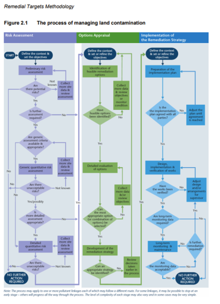
Groundwater risk assessments generally follow the same tiered approach that occurs for Human Health Risk Assessment (Land contamination risk management (LCRM) – GOV.UK).
The principles of Groundwater/Controlled Waters Risk Assessment are as follows:
Phase 1: An initial (screening) level risk assessment is based on models using default assumptions and conservative scenarios. A series of scenarios may be used to take into account variation in geographic and climatic conditions.
Specific Consideration for controlled waters could include:
- Presence of groundwater aquifers – unconfined, confined or a mixture of both
- The aquifer type – principal, secondary or unproductive strata
- Sensitive groundwater locations such as source protection zones or safeguard zones
- The vulnerability of the groundwater to pollution
- The likelihood of perched groundwater
- Any abstraction points or wells on or close to the site – this includes private water supplies
- The presence of and proximity to other controlled waters such as surface water and coastal
- Any available water quality information
- Information on characteristics such as the likely groundwater flow direction and how extreme weather events could impact flows.
The risk assessment process – should plausible pollutant linkages be found – will then move on the to the Generic phase: G&W Guide to… Tier 2 Contamination Risk Assessments
You may need to collect more detailed information on hydrogeological and hydrological properties of the site including:
- Depth to water table
- Thickness of saturated zone
- Presence of perched groundwater
- Groundwater chemistry
- Hydraulic gradient
- Groundwater flow direction and other hydraulic properties
- Direction and rate of flow of surface water under low flow (Q95) conditions
- Seasonal variations in groundwater table and surface waters
- Surface water chemistry
- How climate change and extreme weather events could impact all of these.
IMPORTANT – Detailed Quantitative Risk Assessment for Controlled Waters can be very complicated. Getting it wrong can mean getting stuck in planning (not getting vital conditions closed off) and mired in expensive discussions with the EA.
Taking a proactive investigatory and precautionary approach early on does help. For example, if a Tier 1 Risk Assessment suggests an offsite source affecting your development, a Site Investigation Scheme proving this is probably more likely to be agreed than if just the theory.
Detailed Quantitative Risk Assessment for Controlled Water is generally undertaken using the Land contamination: remedial targets methodology (RTM). Hydrogeological risk assessment guidance and tools then set targets to remediate (clean up) contaminated land or groundwater.
An Excel spreadsheet models the leaching (dissolving of soil contaminants in rainwater) of contaminants and its potential impact on groundwater and controlled waters (river/compliance borehole) or models what happens to contamination in groundwater, and whether it dilutes and attenuates as it flows away from the site.
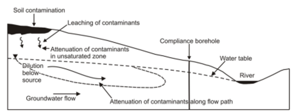
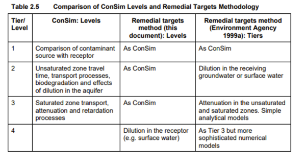
ConSim is like RTM but is able to analyse the attenuation of contaminants in the unsaturated zone better.
NOTE – The input parameters for these models are critical.
 In most scenarios site-based data is essential.
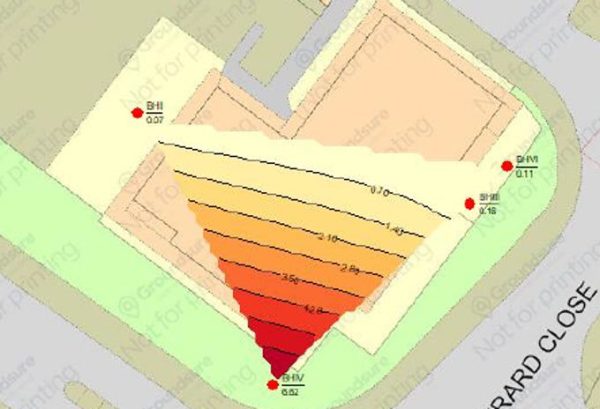
Some of the biggest parameters which affect the model are the groundwater flow characteristics and the degree of degradation that occurs.
Items like aquifer thickness and gradient/conductivity can make remedial targets change by an order of magnitude of 10 to 100. Getting degradation in groundwater can also mean going from a contaminant being an issue to disappearing completely over 30m.
NOTE: The investigation required to get these onsite units can be expensive, especially if it involves a deep chalk/sandstone aquifer or similar.
The point at which you set your “red line”, aka the compliance point, is also vital and however far you might want it from the site, the EA will demand it is closer:
Further guidance can be found here: Land contamination groundwater compliance points: quantitative risk assessments – GOV.UK
So how can Ground & Water help?
Ground & Water is well versed in Groundwater and Controlled Water Risk Assessments. They are quite nuanced, and the EA can be very demanding, so at times we work with industry specialists, to get them right. But Ground & Water has the knowledge to make a difference with RTM risk assessments and help get your site through planning.